Select NOAA-NWS Forecast Office Text Products
(Product availability varies with seasons, forecast office, and weather.)
Hazardous Weather Outlook for St. Louis, MO
To Select Another NWS Office Click on Map or Choose from List
|
| Select Forecast Office: | Select Product: |
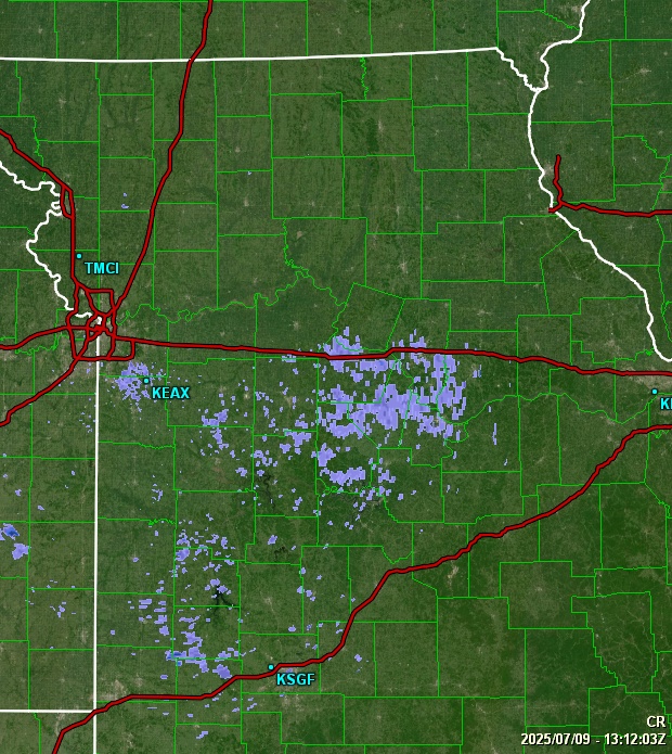
900 FLUS43 KLSX 282055 HWOLSX Hazardous Weather Outlook National Weather Service St Louis MO 355 PM CDT Tue Apr 28 2026 ILZ058>060-064-065-069-070-074-079-095>102-MOZ018-019-026-027- 034>036-041-042-047>052-059>065-072>075-084-085-099-292100- Greene IL-Macoupin IL-Montgomery IL-Bond IL-Fayette IL-Clinton IL- Marion IL-Washington IL-Randolph IL-Adams IL-Brown IL-Pike IL- Calhoun IL-Jersey IL-Madison IL-Saint Clair IL-Monroe IL-Knox MO- Lewis MO-Shelby MO-Marion MO-Monroe MO-Ralls MO-Pike MO-Boone MO- Audrain MO-Moniteau MO-Cole MO-Osage MO-Callaway MO-Montgomery MO- Lincoln MO-Gasconade MO-Warren MO-Saint Charles MO-Franklin MO- Saint Louis MO-Saint Louis City MO-Jefferson MO-Crawford MO- Washington MO-Saint Francois MO-Sainte Genevieve MO-Iron MO- Madison MO-Reynolds MO- 355 PM CDT Tue Apr 28 2026 This Hazardous Weather Outlook is for portions of eastern and central Missouri as well as west central and southwest Illinois. .DAYS ONE THROUGH SEVEN...This afternoon through Monday. More detailed information can be accessed at: https://www.weather.gov/media/lsx/DssPacket.pdf The Area Forecast Discussion is available at: https://forecast.weather.gov/ product.php?issuedby=LSX&product=AFD&site=lsx .KEY MESSAGES... -There remains a 40-90% chance of showers and thunderstorms, primarily this evening. A few severe thunderstorms are possible across parts of southeast Missouri and southwest Illinois through early this evening. -Mainly dry weather is expected the rest of the week with below normal temperatures. NOTE: Starting May 29, 2026, the Hazardous Weather Outlook will be discontinued. Please see the above products for more detailed forecast information. $$ WFO LSX |
Previous Hazardous Weather Outlooks may be found at
NWS St. Louis, MO (LSX) Office Hazardous Weather Outlooks.
(Click 'Previous Version' there to view past versions successively.
Some may differ only in time posted.)
Products Courtesy of NOAA-NWS
NWS Information Parsing Script by Ken True at Saratoga Weather - WFO and Products Scripts by SE Lincoln Weather.
Mapping by Curly at Michiana Weather and by Tom at My Mishawaka Weather.