| NWS Weather Forecast -
Outlook Overnight & Thursday |
Overnight

Chance Showers And T-Storms
Lo 59°F ↑
|
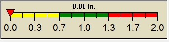
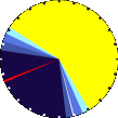
NWS forecast: A chance of showers and thunderstorms. Cloudy. Low around 59, with temperatures rising to around 63 overnight. Southwest wind around 3 mph. Chance of precipitation is 50%.
WXSIM forecast: Dense overcast. Patchy light fog in the afternoon. A chance of rain. Precipitation showery or intermittent. High 64°. Wind southwest around 8 mph, gusting to 15 mph. Chance of precipitation 50 percent. Precipitation mostly less than a quarter of an inch.
Local station forecast: Mostly cloudy with a chance of thunderstorms. Showers likely, mainly this morning. Highs in the mid 70s. Southwest winds 5 to 10 mph. Chance of rain 70 percent. |
Thursday

Chance Showers And T-Storms
Hi 74°F
|
NWS forecast: A chance of showers and thunderstorms before 7am, then showers and thunderstorms likely between 7am and 11am, then a chance of showers and thunderstorms. Mostly cloudy, with a high near 74. Southwest wind 5 to 10 mph. Chance of precipitation is 60%.
WXSIM forecast: Cloudy. Patchy light fog in the evening. A slight chance of rain. Precipitation showery or intermittent. Low 58°. Wind southwest around 2 mph in the evening, becoming east after midnight. Chance of precipitation 20 percent. Precipitation mostly less than a tenth of an inch.
|
|
| NWS Short Term Weather Forecast |
|
Thursday
Night

Chance Showers And T-Storms
|
Friday

Chance Showers And T-Storms
|
Friday
Night

Chance Showers And T-Storms then Partly Cloudy
|
Saturday

Mostly Sunny
|
Saturday
Night

Mostly Clear
|
Sunday

Sunny
|
Sunday
Night

Partly Cloudy then Chance Showers And T-Storms
|
|
Lo 59°F |
Hi 76°F |
Lo 58°F |
Hi 81°F |
Lo 60°F |
Hi 86°F |
Lo 65°F |
|
ajax-dashboard6.php - Version 6.95e - 01-Feb-2022 - Script by: Scott of BurnsvilleWeatherLIVE.com
Now supported by Saratoga-weather.org Download
|