Warning: DOMDocument::load(): Opening and ending tag mismatch: meta line 27 and head in http://feeds.enviroflash.info/rss/realtime/134.xml, line: 28 in /home/staff/ed/eds-weather.info/www/get-aqi-rss.php on line 37
Warning: DOMDocument::load(): attributes construct error in http://feeds.enviroflash.info/rss/realtime/134.xml, line: 33 in /home/staff/ed/eds-weather.info/www/get-aqi-rss.php on line 37
Warning: DOMDocument::load(): Couldn't find end of Start Tag script line 33 in http://feeds.enviroflash.info/rss/realtime/134.xml, line: 33 in /home/staff/ed/eds-weather.info/www/get-aqi-rss.php on line 37
Warning: DOMDocument::load(): StartTag: invalid element name in http://feeds.enviroflash.info/rss/realtime/134.xml, line: 38 in /home/staff/ed/eds-weather.info/www/get-aqi-rss.php on line 37
Warning: DOMDocument::load(): Opening and ending tag mismatch: meta line 25 and html in http://feeds.enviroflash.info/rss/realtime/134.xml, line: 42 in /home/staff/ed/eds-weather.info/www/get-aqi-rss.php on line 37
Warning: DOMDocument::load(): Premature end of data in tag meta line 24 in http://feeds.enviroflash.info/rss/realtime/134.xml, line: 42 in /home/staff/ed/eds-weather.info/www/get-aqi-rss.php on line 37
Warning: DOMDocument::load(): Premature end of data in tag meta line 23 in http://feeds.enviroflash.info/rss/realtime/134.xml, line: 42 in /home/staff/ed/eds-weather.info/www/get-aqi-rss.php on line 37
Warning: DOMDocument::load(): Premature end of data in tag meta line 4 in http://feeds.enviroflash.info/rss/realtime/134.xml, line: 42 in /home/staff/ed/eds-weather.info/www/get-aqi-rss.php on line 37
Warning: DOMDocument::load(): Premature end of data in tag head line 3 in http://feeds.enviroflash.info/rss/realtime/134.xml, line: 42 in /home/staff/ed/eds-weather.info/www/get-aqi-rss.php on line 37
Warning: DOMDocument::load(): Premature end of data in tag html line 2 in http://feeds.enviroflash.info/rss/realtime/134.xml, line: 42 in /home/staff/ed/eds-weather.info/www/get-aqi-rss.php on line 37
Notice: Undefined offset: 0 in /home/staff/ed/eds-weather.info/www/get-aqi-rss.php on line 48
Notice: Undefined offset: 0 in /home/staff/ed/eds-weather.info/www/get-aqi-rss.php on line 58
Notice: Undefined offset: 0 in /home/staff/ed/eds-weather.info/www/get-aqi-rss.php on line 72
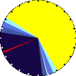
13 h 22 m 2 s of Sunlight Yesterday 13 h 24 m 14 s of Sunlight Today
Which is 2 min 12 sec longer than yesterday 13 h 26 m 25 s of Sunlight Tomorrow (Noon)(Midnight)
1 Rain season: Jan 1st to Dec 31st.
2 Snow season November 1st to April 30th.
3 Snow manually measured usually around 7AM and 7PM.
4 Updated at Noon Central Time.
5 Estimated amount of water needed to replace the water used by plants and evaporation from the past week. (Negative numbers mean amount of water needed, positive numbers mean excess water is present).
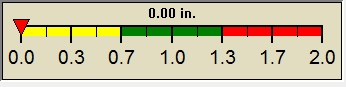
6 Air Quality Index is provided by Minnesota Polution Control Agency and is updated hourly between the hours of 6AM and Midnight.
7 Leaf Wetness is surface moisture on foliage. 0 being totally dry and 15 being totally saturated.
8 Soil moisture and temperatures are from sensors burried in the ground at the levels specified.
10 Historical average only to day 20 of just the month of April for this station since 2007.
11 Historical average rain this season to day 20 of April for this station since 2007.
NWS Weather Forecast -
Outlook Today & Tonight
Today
Mostly Sunny
Hi 57°F
NWS forecast: Mostly sunny, with a high near 57. Northwest wind 7 to 15 mph, with gusts as high as 23 mph. WXSIM forecast: Partly to mostly sunny in the morning, becoming partly to mostly cloudy in the afternoon. High 55°. Wind chill ranging from 38 to 49. UV index up to 5. Wind north-northwest around 10 mph, gusting to 21 mph. Local station forecast:Mostly sunny. Highs in the upper 50s. Northwest winds 10 to 15 mph with gusts up to 25 mph.
Tonight
Partly Cloudy then Areas Of Frost
Lo 35°F
NWS forecast: Areas of frost after 4am. Partly cloudy, with a low around 35. Northwest wind 6 to 12 mph. WXSIM forecast: Mostly cloudy to cloudy in the evening, becoming partly cloudy after midnight. Low 35°. Wind north-northwest around 5 mph.
NWS Short Term Weather Forecast
Sunday
Areas Of Frost then Sunny
Sunday Night Clear then Areas Of Frost
Monday
Areas Of Frost then Sunny
Monday Night Partly Cloudy then Slight Chance Rain Showers
Tuesday
Chance Rain Showers
Tuesday Night Chance Showers And T-Storms then Partly Cloudy
Wednesday
Sunny
Hi 60°F
Lo 35°F
Hi 68°F
Lo 50°F
Hi 70°F
Lo 43°F
Hi 66°F
ajax-dashboard6.php - Version 6.95e - 01-Feb-2022 - Script by: Scott of BurnsvilleWeatherLIVE.com
Now supported by Saratoga-weather.org Download